20 Mar 2026
Urban expansion around major Indian cities is increasingly driven by infrastructure-led planning rather than organic sprawl. In this context, Dholera Smart City Ahmedabad has emerged as a significant development initiative, designed to complement Ahmedabad’s growth through a structured, future-oriented urban framework. Planned as a greenfield smart city under Gujarat’s Special Investment Region (SIR) policy, Dholera is positioned to function as an integrated industrial and urban center supported by large-scale infrastructure and multimodal connectivity.
The association between Dholera Smart City and Ahmedabad is not incidental. Ahmedabad acts as the primary urban anchor, while Dholera is envisioned as a planned extension that absorbs future industrial, logistical, and residential demand through modern infrastructure systems.
Ahmedabad has evolved into one of India’s major metropolitan regions, with strong industrial, educational, and commercial foundations. However, rapid urbanization has also increased pressure on land availability, transport systems, and civic infrastructure. Dholera Smart City Ahmedabad is designed to address these challenges by creating a new urban-industrial zone outside the congested metropolitan core.
Rather than expanding Ahmedabad through unplanned peripheral growth, the Dholera model focuses on decentralization. Large land parcels, pre-defined zoning, and integrated infrastructure planning allow development to occur in a controlled and scalable manner, aligned with long-term regional planning objectives.
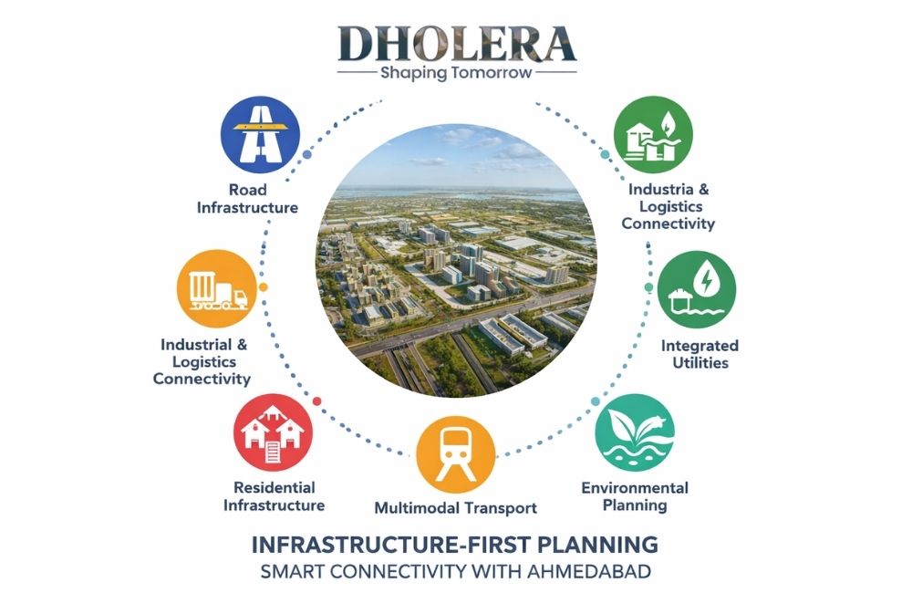
One of the defining aspects of Dholera Smart City Ahmedabad is its infrastructure-first development approach. Unlike conventional urban growth, where infrastructure is often added reactively, Dholera’s planning prioritizes core infrastructure before large-scale occupation.
This philosophy ensures that:
Infrastructure planning is treated as the foundation on which economic and residential development is built.
Road infrastructure plays a central role in linking Dholera Smart City with Ahmedabad and other regional nodes. The city’s master plan includes a hierarchical road network consisting of arterial roads, sub-arterial roads, and internal streets.
Key characteristics of the road network include:
This structured approach improves traffic flow and reduces the likelihood of bottlenecks commonly seen in organically developed areas.
Connectivity between Ahmedabad and Dholera Smart City is a critical factor influencing the project’s long-term relevance. The planning framework emphasizes seamless regional integration to support daily commuting, industrial logistics, and service access.
The Ahmedabad–Dholera corridor is designed to:
By functioning as a complementary urban zone, Dholera reduces pressure on Ahmedabad while remaining closely linked to its economic ecosystem.
Dholera Smart City Ahmedabad is planned around a multimodal connectivity model, recognizing that future urban regions require diversified transport systems. Rather than relying on a single mode of transport, the city integrates road-based connectivity with provisions for rail, freight, and future transit systems.
The multimodal framework supports:
Such integration enhances resilience and reduces transport-related inefficiencies.
Industrial viability depends heavily on reliable logistics and transport access. Dholera Smart City Ahmedabad is planned as an industrial-supportive region, with infrastructure tailored to manufacturing and export-oriented activities.
Connectivity planning addresses:
This infrastructure orientation strengthens Dholera’s position as a logistics-friendly industrial destination.
Beyond transport, Dholera Smart City Ahmedabad places strong emphasis on integrated utility infrastructure. Utilities are planned as part of a unified system rather than independent networks.
Core utility planning includes:
Placing utilities underground not only improves urban aesthetics but also enhances reliability and simplifies long-term maintenance.
Digital infrastructure is an essential component of modern urban planning. Dholera Smart City Ahmedabad incorporates smart systems to support governance, service delivery, and infrastructure management.
Smart infrastructure elements include:
These systems are designed to improve efficiency, transparency, and responsiveness at the city level.
Given its geographical context, environmental planning and flood management are integral to Dholera Smart City’s infrastructure framework. Rather than relying on post-development mitigation, environmental safeguards are embedded in the planning process.
Infrastructure measures include:
This approach reduces environmental risk while supporting long-term urban resilience.
Infrastructure planning in Dholera Smart City Ahmedabad is not limited to industrial or transport systems. Residential zones are supported by planned civic and social infrastructure designed to meet future population needs.
These provisions include:
Such planning supports the development of a balanced urban environment rather than a purely industrial township.
A critical advantage of Dholera Smart City Ahmedabad lies in its scalability. Infrastructure systems are designed to accommodate phased growth over several decades without major structural overhauls.
This scalability ensures that:
Long-term adaptability is a key factor distinguishing Dholera from conventional urban extensions.
From a regional planning perspective, Dholera Smart City Gujarat functions as a strategic node within Gujarat’s broader urban and industrial network. It complements existing cities rather than competing with them, enabling more balanced regional development.
By linking infrastructure planning with connectivity and land use, the project supports:
This coordinated approach reflects a shift toward smarter regional planning.
Dholera Smart City Gujarat represents a structured response to the challenges of metropolitan expansion. Through infrastructure-first planning and integrated connectivity, the project aims to support Ahmedabad’s growth while avoiding the pitfalls of unplanned urban sprawl.
By combining transport networks, utility systems, digital infrastructure, and regional connectivity within a unified framework, Dholera sets a precedent for future urban development models in India. Its success will depend on phased execution and long-term governance, but its planning foundation positions it as a key component of Gujarat’s evolving urban landscape.
Your information is safe with us. By submitting, you agree to our privacy policy and terms of use.